"Geocaching is an outdoor treasure-hunting game in which the participants use a Global Positioning System (GPS) receiver or other navigational techniques to hide and seek containers (called "geocaches" or "caches") anywhere in the world. A typical cache is a small waterproof container containing a logbook and "treasure," usually toys or trinkets of little monetary value. Today, well over 410,000 geocaches are currently placed in 222 countries around the world, which are registered on various websites devoted to the sport."

This is my son "Devo"
In his Grandfathers Balmoral Hat.*
In typical British style they do what is called "Geographing".
Here is the Geograph websites explanation:
The Geograph British Isles project aims to collect geographically representative photographs and information for every square kilometre of the UK and the Republic of Ireland, and you can be part of it.
What is Geographing?
- It's a game - how many grid squares will you contribute?
- It's a geography project for the people
- It's a national photography project
- It's a good excuse to get out more!
- It's a free and open online community project for all
The aim of the Geograph website is to be a widely appealing web site that will gradually produce a freely accessible archive of educationally useful, geographically located photographs of the
The Ordnance Survey grid has been chosen as the basis for the geographic referencing system.
To get an idea of the type of image we are interested in, think what a child sat looking at a map in a geography lesson might find useful when trying to make sense of what a the human and physical geographical features in a given grid square actually look like, or what would he see if he looked further a field from a given viewpoint.
Blah, Blah, Blah Blog....Their website is: http://www.geograph.org.uk/
"So why are you doing this to us obee?"
And then I found Geograph.
And my Girl friend "Anonymous" responded with a "yeah, so..." But I have been wondering just what this place looked like for most of my adult life. ..And this is a BIG deal to me!
 This is a map of modern day Killaloo.
I would like to take you
on a Geograph Virtual tour:

On some maps the townland is spelled "Oughtagh".

2) Newcumber Presbyterian Church.
Located at Killaloo.

3) Killaloo Orange Hall.
Located at Killaloo.

4)
Derry & Raphoe is the Diocese which Cumber parish is in.

Looking towards Slieveboy** in the distance.
(That is rush in the foreground)
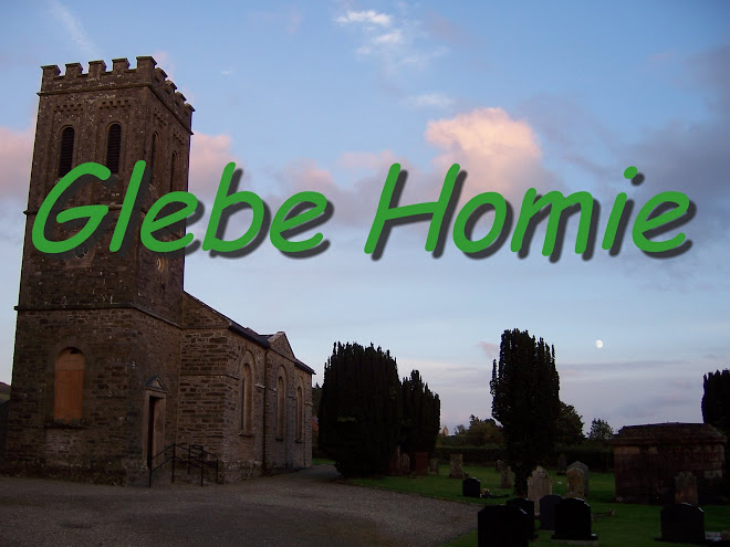
...and yes, this is where my new Blog Header came from...

5) Killaloo.
Lettermire Hill is in the background.

6) Looking towards Brackfield Townland.
In the direction of Lettermire Hill.

6 also)
Some new plantings are protected by a fence.

Some maps use a spelling variation of Kiltcaltan.

8) Road at Toneduff.
Heading in the direction of Claudy.

9)
Located at Brackfield near

9 also) The
The Burntollet river where it emerges from the
It flows into the river Faughan, about two kilometres
to the south west of here at

10) Lettermire Hill. (great wet hill-side.)
Looking eastwards across the slope of the hill.
11) Slieve Kirk.
Not pictured here, but indicated
on the map as a reference point.
(not to be confused with Slieveboy.)

12) Legaghory Townland.
Looking east to Killaloo.
this concludes our tour for today.
Thank-you very much for coming!
Have a nice day....
9 also), "The
*Obviously this blog has little or nothing to do with him or the hat, I just think its a neat portrait and I was itching for a reason to use it....
**"Slieveboy" is Southeast of Killaloo, it lies off of this map to the lower right hand corner, towards Claudy, not to be confused with "Slieve Kirk in the lower left hand corner of the map indicated by the # 11)
Came across your website by accident and believe it or not i live about 2 miles down the road from Claudy in a place called Drumahoe. G Chambers
ReplyDelete